


Day One
Four am came early, but I was up to the challenge. I hopped out of bed and was on the road by 4:10 am. Made it to Exit 63 on Interstate 85 by 6:18 pm—about eight minutes later than I estimated. Not bad. Starting mileage was 16,123.3 and ending was 16,709.5, making for a long day in the saddle of 586.2 miles and eight minutes more than the 14 hour estimate I gave myself. I figured my fuel consuption so far and it varied between 52 and 59 mpg. Interestingly, the best mileage was not on premium non-ethanol (the first tank) but on ethanol premium. I was able to run 60+ mph most of the time on these back roads with virtually no traffic. In spite of the recently reupholstered saddle my butt is sore after that many miles, but on the old saddle I would now be dead.
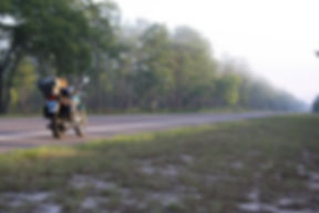
Here is my bike in the Ocala National Forest about sunrise.

There was dense fog there mixed with smoke from wildfires; it was almost overwhelming at one point. The smoke eventually dissipated, but I had it in some degree almost to Vidalia. The sun was just starting to rise while in the Ocala Forest. Funny thing, which I have noticed when hunting, is the coldest time of day is not before light but just after sunrise—I was shivering this morning at that time, although I was comfortable riding in the dark. Once past the opening cold of the new day, the east Georgia temps rose and rose. By mid-day I was burning up and decided to get out my evaporative vest. That helped for a couple hours until it dried out and then became another heating layer. By that time it was not quite as sweltering, so rather than wet it again, I rolled it up and put it away. My mesh jacket did a reasonable job after that of keeping my temp down, as long as I wasn't sitting at a light; luckily there are very few lights along my route through eastern Georgia.
The route was relatively trouble-free. I did have a near panic attack once when I had flipped over to reserve and kept stopping at gas stations that either had no premium or had bags over the pump handles. I never ran out, but I put close to 2.4 gallons in a 2.5 gallon tank when I finally found fuel.
There was very little traffic the whole way up, except when I started my approach to Greenville. The roads were smooth and empty, mainly two lane, but some lonely divided four-lane also. I was able to keep a pretty steady 60 to 64 mph. There were a couple instances of road work, but only one where I had to wait for one-way oncoming traffic to pass. That was on top of the dam on the SC border and was only a five minute wait.
I had to stop a couple times to get my bearings, but those were a couple minutes looking at the map and back on the road. The only time I had to do a turn-around was in Wrens, where I was supposed to pick up US 221 northeast into SC and to Greenville. Now, 221 runs clearly northeast but here it was clearly marked west. I drove past the obviously wrong turnoff and eventually pulled into a car lot and asked a lady working there. She assured me I wanted US221 west, really. Luckily I was not more than a mile past my turn so I headed back and onto US221 west. I never did figure that one out, but she was right.
Here's the route which I would recommend: US27 north to FL561 to FL19 through Mt. Dora and the Ocala National Forest. After the forest, it was FL 310 west to FL315 and then north. (I had marked this 215 on my map, making for a confused rider, but I had marked it correctly further on, so I figured I had to eventually be on it anyway, and carried on.) 315 joined FL21 that took me to Middleburg, FL where I caught FL218 northwest to US301 which carried me to Callahan, FL. From there I took US23/US1 into GA at Folkston and north to GA15/GA121 which went north and reconnected with US 1 at Baxley, GA. I took US1 to Wrens and US221 west (yes, west). US 221 took me into SC at the Strom Thurmond Reservoir and almost all the way to Greenville. Tim lives actually between Greenville and Spartanburg at Exit 63 on I85, I had to take a turn to the north on SC290 to the exit and Tim's place.
The border between GA and SC is formed by the Strom Thurmond Reservoir. Here's a pic of my bike at the dam.

Failures today include a continuing oil leak, in spite of my recent re-gasketing. It was minor and although I checked every two fuel stops, it never required an oil. And the tach stopped working this afternoon, but that's OK, it was a tach I picked up cheap at a flea market to use while I got my old one repaired.
Here's a pic of me parked next to Tim's Kawasaki Nomad 1500 at his Greenville (Duncan) digs.

Saturday, it's the mountains for us and probably Maggie Valley.
I will try to post tomorrow.
Cheers,
Mike aka Road Dog


